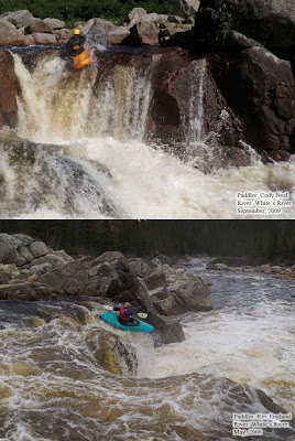
Showing posts with label newfoundland and labrador. Show all posts

Sunday, April 04, 2010

Ides of March

I know it's April, and this trip took place in April, but the creek is called March Brook and it does have 15 rapids. This post is a quick update on this steep creek and a small crew that went for a mini-epic on Sunday. A new, easy access route was confirmed and three new rapids at the top of the river were added to the inventory of known waterfalls on the brook.

The first waterfall on March Brook.

I've been captivated by March Brook since my first hike up the bottom portion of the creek in 2001. The first descent in 2002 was hampered by the fact that it was -7C and two of us were in unfamiliar, brand-new creek boots. However, that didn't stop Kev England from stomping six of the seven big, manky waterfalls while the rest of the crew watched. Ever since I've wondered, perhaps obsessed, if it was the day or me that held me back from running more of the drops.

Now I know, it was me. In stark contrast to the first descent Sunday was 15C and sunny, perfect conditions for an exploration trip. The first order of business was to establish a new hiking route into the upper reaches of the brook. Isaac, Erlangga and I followed a well used quad trail to a plateau of barren lands east of Pipers Hole Brook. The views of the area are fabulous up here and even better there is no bush crashing. And in a bizarre turn of events Erlangga voluntarily dragged my boat part of the way.

I didn't check the time, but our 5 km hike to the put-in took about an hour and a half. The quad trail is well used and can't be missed on the hike up Pipers Hole River, once on the trail take every left. The idea is to skirt the tree line along the western edge of the bog, so eventually you have to leave the quad trail. We left the trail at the height of land and followed a creek down to the first rapid on March Brook. This route is pretty obvious on the high resolution Google Earth image.

One of the main points of this trip was to find out how many waterfalls were present above the 2002 put-in. We found one class IV rapid that consisted of two broken ledges. Below this rapid is a distinct, river wide horizon line that marks a 3 m waterfall. There are multiple lines on this drop and it is pretty straight forward. I chose a line that was not obvious until I was downstream scouting the next horizon line. This drop makes for a very motivating start to March Brook.
Landing the first waterfall, just to prove I can boof.
The next horizon is misty and simply feels bigger than the first waterfall upstream. The waterfall is 6 m high and is defined by a u-shaped ledge. An ugly looking pocket forms at the upstream end of the U, but there was a lot of water flushing downstream on the river left side of the drop and I don't think getting stuck would be a problem for very long. Still, being a Nervous Nelly I chose the conservative line on the extreme downstream side of the ledge on river left. This end of the ledge lands entirely on water flowing out of the drop and is a pretty easy line to hit and you still get airborne for 6 m. Mind you I could have made it look prettier with a proper boof.
On the brink of the second waterfall. This can't end well.

At the next horizon line the trip started to disintegrate. I scouted on river left while I waited for the safety guys to bush crash their way downstream. This is the first waterfall that Kev ran in 2002 and it was taller (7.5m) and mankier than I remember, not to mention there was a whole lot more water in the brook. However, there are two lines on the drop that skilled, committed paddlers could hit. The difficulty of the waterfall is greatly increased by the mandatory blind corner that is itself a 4.5 m waterfall into a stout hole and forms the run-out of the first drop.
A 2002 photo from downstream of the fourth rapid on March Brook, a 7.5 m waterfall. This photo makes it look smaller than reality.

I started walking at this point and my boat didn't see water until I was at Pipers Hole River. There a few factors that contributed to this disappointing end to the day: first and foremost I was in over my head, the water level was higher than expected and the drops were beefy, and finally I would have been completely on my own in the canyon. Isaac and I think that more of the brook would be runnable if your entire team were in boats at river level. Scouting and safety set-ups are required on both sides of the brook so the team needs to maneuver back and forth across the brook. Furthermore, portaging is generally easier from the river right bank.

So, what are the take aways from Sundays mini-epic? There is new, easily hike-able access to March Brook. The first three rapids and waterfalls are fun and very runnable. The rest of the canyon is really hard whitewater, but it is runnable by folks with the requisite class V to V+ skill set; lesser mortals may still be able to safely pick away at a few of the waterfalls in the main canyon. The last take away is a comment on water levels. I previously thought March Brook required very high water on Pipers Hole River (2.5m to 3m) to be runnable. However, yesterday Pipers was fairly low, maybe 1.1m to 1.2m on the gauge, all the feeder brooks that people are familiar with were trickles, and March Brook was still at what is probably the high-end of medium for this brook. I'm at a loss to explain this correlation, but I did note that on Saturday and Sunday the Northwest River, the adjoining catchment basin, was on the rise. Perhaps there was still snow higher in the drainage area, but that is hard to imagine this year. Whatever the reason I would revise level expectations for March Brook. My new hypothesis is that March Brook is likely to be at viable levels any time Pipers Hole River rises to playable levels. This scenario would greatly increase the season for March Brook.

Now on a final note. I have this monkey off my back, I now know what lies upstream on March Brook. The question remains, will I go back. Maybe, but only if Isaac wants to return when his back has finished healing. It will definitely be at lower water and the whole team will be on the river. Besides, I have a water level hypothesis to test.

Monday, March 08, 2010

A Chinese Riot on Petty Harbour River

Last week more than 100 mm of rain fell on St. John's, NL. I didn't want the ski season to end, but that much rain, combined with snow melt, means the creek boating on the Avalon Peninsula is phenomenal. For a few brief weeks every March or April multiple class IV and V creeks run within a 20 min drive of the province's capital city.

Cody Neal stomping the line on the first waterfall.

This spring I had a brand new, never seen the water Riot Magnum that was manufactured in China. There were two things about this that bothered me: I hate unscratched boats and I was unsure about the durability of my new boat. Excited to be able to address both these issues I floated a plan out to the local crew for a run on Rennies Mill Brook. This brook runs through St. John's, changing names at every pond, but the section from Columbus Drive down to the old mill site consists of several class IV to V drops at flood levels. However, through a series of disjointed emails and phone calls it was settled that we would head to Petty Harbour to run the lower section of the river there.

Petty Harbour is a relatively short (1 km in length), high-gradient run located about a twenty minute drive southeast of St. John's. Construction of the first hydro-electric power project in the province was started in 1898 and the river bed has been dewatered since 1900. Fortunately during huge rain events and spring melt the reservoir comes up 1.5 m and flows over the dam, bringing a high quality class V run to life. The first descent was during the 2001 hurricane season by Kevin England. Due to the paucity of flowing water and sheer difficulty of the rapids Petty Harbour River has only seen a few complete and partial descents since 2001. All of the class V drops are located in the first half of the run and the lower half consists of a 4 m waterfall and three steep, class IV boulder gardens. This section was the 2010 season opener.

Working our way through the boulder garden rapids.

I've scouted the river several times and have always walked away from the sieves and pourover ledges in the upper section without considering the lower half of the river. Cody Neal and Dave MacDonald ran this section at medium to low water levels couple of years ago and gave it a good review. On Sunday morning looking at the section in flood and a temperature of -1C the pucker factor was high and I found myself wondering why I wasn't launching into the polluted waters of Rennies Mill Brook. Once I was in my boat and comfortably numb from the cold water on my face I remembered why I was there; 4 m waterfalls with tricky lines are the best way to start the season. Plus, I'm not going to get sick from drinking the water.

Chris Buchanan shaking off the winter cobwebs on Petty Harbour River.

Cody and I both had good lines on the waterfall and this settled our nerves for the next three boulder garden rapids. In the first one I had to make a hasty ferry to avoid running over a broached Cody and ended up pitoning hard as I came over the wave. A dented bow was a forgone conclusion and the second piton left me without a doubt that my boat was no longer a virgin. Next time I'll just run Cody over. The thing that struck me about the lower section of Petty Harbour River wasn't the difficulty or that the holes were much meatier than they looked from the river bank, but that overall the rapids were easier than I thought during the scout.

The dents in my boat after less than 15 minutes on the river.

At the end of the day Petty Harbour River deserves its position as an Avalon classic and I agree with the boys that when it runs everything should be dropped to get in a run on it. I hope it is warmer next time and we can consider running from the dam down to the ocean. At the very least, the 200m of river upstream of the waterfall looks like fun and manageable constant gradient whitewater. Thanks to Dave MacDonald, Dave Ennis, and my father for the photography and video.

Friday, January 15, 2010

Labrador Access on the Trans-Labrador Highway

Wow, two posts in a week, let alone a year. This is just a brief note about improved access to rivers in southern Labrador. Over the holidays I saw a news article that was about the first two vehicles to travel over the recently completed trans-Labrador highway. This is great news for paddlers. It is now possible to drive from Blanc Sablon on the south coast of Labrador to, well, anywhere on the continent.

When I first started map research in the province I noted several runs east of the Pinware River which have the right topo characteristics to be great creeking. Until now access was a bit miserable though, but the new road comes very close to the headwaters of several of these runs. The road may also provide access to rivers that were previously accessible only by flying. At the very least you'll only have to fly to the put-in. However, the challenge remains in getting back to civilization once you hit the ocean. Communities are far and few between here, but I'm sure locals would be amenable to fishing boat pick-ups.

I hope this highway heralds a new era of river exploration in southern Labrador. Even the ability to drive gear and supplies to Goose Bay will reduce costs for getting teams into the more isolated northern rivers. Anyone want to go and see what the Torngats have to offer?

If you take advantage of the highway for paddling, hopefully you'll let me know and contribute to the database of river knowledge in the Newfoundland and Labrador.

Sunday, January 03, 2010

September, 2009: The West Coast of Newfoundland

My New Year's resolution this year, well there is two, write a post about a White's River trip in September and finish my thesis this year. Here is the first one done and let’s hope the second is as easy. This post describes a road trip in September, 2009 to paddle the White’s River in western Newfoundland. I was using a new camera on this trip and I’m not pleased with a lot of the river pictures, so I apologize in advance for image quality.

After a month in the bush I found myself with a few spare days, a vehicle, and a paddling partner. To sweeten the deal the island had a fair bit of rain just before I came out of Labrador and rivers were running. Unfortunately only Cody Neal could make the trip, but we were determined to get on a few west coast classics. I flew through Deer Lake on the way home and was able to scout the White's River, excellent water levels, but from a few thousand feet it's hard to tell and maybe there would be too much water. Cody and I left town just after lunch with the intent of spending the night at Rafting Newfoundland with Paul Rose.


First waterfall on Eels River. My battery died before Cody ran it.

Along the way we stopped at Eels River, just east of Norris Arm on the TCH. Paul discovered and opened up this run a few years ago, but I've never been there when it had water. Cody and I found enough water for the first waterfall and suited up. The first waterfall was great and we ran it a few times, but downstream of this was way too bony. I'd say we were a day too late for decent flows on this little river. However, it has some nice drops and with enough water it would be a great, full-on run.

We should have skipped Eels River and gone straight to Leech Brook. There was enough water that evening, but it was dark and things were dropping fast which meant Cody didn't get his chance to launch Second Falls. At Paul’s place we monitored Aspen Brook overnight, but after sleeping-in decided it was better to head west than waste time with a waterfall that was at marginally low levels. The landing zone already looked like a pretty hard hit compared to my previous runs on this classic drop. So, west we went.

In the first box canyon of Upper Lomond River.

Fortunately for us my parents were on the island and agreeable to running shuttles. In hindsight they might have regretted this offer. Our first run was Upper Lomond Brook. This is a section of river that includes several beefy drops in committing box canyons. It defeated us on the first descent, felt sketchy on the second descent, and was fun on the third. Cody on the other hand has a contradictory opinion of this river. Although I didn't intend to sandbag him, Cody maintains that I may have under-estimated the visual intensity of this river in previous descriptions. I still think the drops that aren't portaged are class IV to V rapids.

Entrance ledge to the "Access Denied" box canyon.

That said the river is essentially remote, rescue would involve a helicopter, and the consequences of missing any of the lines looks awful. At the end of the day I maintain that Upper Lomond Brook is a classic class V creek, but Cody warns that the undercut, bouldery drops look heinous. The moose burger platter in Wiltondale was still cheap and good though.

The plan after Lomond was to set shuttle for White's River and camp at the put-in. This noble plan quickly turned into a SNAFU. An old logging road accesses a group of cabins on Adies Lake and I had previously suggested that this should be used as the take-out for the White's River. This road is really nothing more than a buffed up skidder trail; it's hard to believe logging trucks ever used it. My Jeep Patriot is a light-weight in the world of off-road vehicles and it was truly tested by this road, but would have made it in the light of day. After creeping down the road at 2 kph in the dark, a strategic retreat was called for by the other participants in the epic and we regrouped in Deer Lake. Early the next morning we headed down the original take-out road on the south end of Adies Lake. In 2006 we drove all the way to the take-out, however, alders have grown in and we were only able to drive to within 500 m of the take-out. At least our shuttle was finally set.

Bridge gauge at the feeder brook put-in. This was very low.

The White’s River logging road was in much worse shape than my last trip into the Long Range Mountains. It will soon require a 4-wheel drive vehicle. The traditional put-in has always been the bridge over a feeder brook to the White’s River, which is where an informal gauge is located. This brook looked low, but the gauge indicated the same level as my 2006 trip. It turned out the feeder brook and upper reaches of the White’s were way to low and lots of boat dragging was required. I’m sure this gauge indicates when the water is way too high for the river, but it is only a vague indicator of low to medium levels. Repeated flights over the White’s and Google Earth indicate that several sets of rapids are located above and below the bridge which crosses the White’s River.

Differences in water levels at the same rapid.

The alternative put-in does not add any river distance to the run and likely adds some good rapids to the start of the day. Also, a gauge on this bridge may provide a more accurate depiction of the levels downstream. These are the gauge levels for the region in September, but I don't have enough data to know how closely these relate to the White's: Main River @ Paradise Pool = 25 cms, Humber River above Black Brook = 28 cms and Humber River @ Reidville = 83 cms

Our run down the White’s was uneventful, but shallow water definitely made the day longer. Here is a picture of a rapid to illustrate the difference in water levels:

A few notes are required to update my previous description of the river:

"Split Lip, " the first major rapid (IV).

1. Once the first major rapid, “Split Lip” is reached there are three class –IV rapids before reaching the first canyon. The third rapid is some distance downstream from the second and is recognized by an obvious, easily avoided boulder sieve on river right. The big waterfall is still a long way downstream from here and there is plenty of time to eddy out above the falls.

Downstream from White's River Falls.

2. The waterfall marks the start of the first canyon. Below the waterfall there are two rapids, class III and IV+, before a rapid that is usually portaged.

3. The only other notable deviation of the original report from reality is in the second canyon. I had described a long pool above the class VI waterfall in this canyon, but forgot about a class III rapid between the blind corner and the waterfall. It isn’t a big deal, but it might as well be known feature.


After leaving the channelized canyon rapids the water almost disappeared on the braided alluvial fan that marks the mouth of the river. This wasn’t much fun, but was far better than the headwind hell that we faced crossing Adies Lake to the take-out. I fully recommend getting a vehicle into the cabins on Adies Lake, it will make the day much shorter. Quads may be useful in shuttling this run, but someone has a motor home parked on Adies Lake so surely we can drive there. This run took Cody and me seven hours, but two of those hours were spent crossing Adies Lake.

One final note: some maps, Google included, indicate that Rd# 422 heads north from Cormack to Sir Richard Squire’s Provincial Park and eventually makes its way to the TCH near the Sop’s Arm turn-off (Rd.# 420). While not exactly wrong, these are barely roads and seem to primarily exist to be snowmobile trails in the winter. At the end of the day it is quicker to back-track to Deer Lake, have a beer and then head north on the TCH.

Sunday, April 20, 2008

Spring has Sprung

The paddling season has finally begun in NL, actually it started in St. John's last weekend. Rivers on the Avalon have been booming and it sounds like people have been taking advantage of the high water. We’ve done a couple of runs on Bay Bulls River and yesterday Cody and I got on Seal Cove River for a very high-water run. I saw a post on the KNL newsgroup for a trip to Salmonier River for a bit of surfing today. It’s nice to have spring and see the crews getting back in their boats.

Here are a few pictures from recent trips that I have been on in the past week.

Bay Bulls River

Seal Cove River

I don't think I'll be in my boat this week, but hopefully next weekend we can start picking away at creeks on the Burin.


Keep your blade in the water and the right-side up.


Tuesday, March 18, 2008

A long winter hiatus

As Dave Mac mentioned in his email the other day, it has been a strange boating winter this year. Snow, rain, more snow. It certainly bodes well for some epic creeking across the island this spring. I have just a couple of housekeeping notes for the website today. I've included a picture of the shuttle rig Steve and I used on our last trip to the Northwest River to demonstrate how our winter paddling season has been this year.

A few prepared locals that made getting into the put-in possible on December 5, 2007

Northwest River
Now that spring is around the corner, right after this blizzard, I'm sure groups will be eager to get on the Northwest River. During a trip in early December Steve Arns and I noticed that a lot of wood was poised to make its way into the river. Since the really high water levels a few years ago wood has been popping up in undesirable spots on the Northwest River. Thankfully it normally washes out fairly quickly. However, in December there was wood in the entrance ledge to the second canyon. A tree extends from the river right canyon wall out into the landing zone for the river-right boof line. It is not very visible from upstream and care should be taken to assess this risk on the next trip or two down the river.

Second Drop on the Golf Course Section. Steve is checking out ice conditions in the entrance to Mulligan.

Google Earth File
Last year I generated a Google Earth file that showed many put-in\take-out locations on the island. A few weeks ago I was looking at this data and I realised that some really important rivers were missing from this dataset. I spent a bit of time here and there to update my maps and make sure the classic whitewater trips are included in the file. I also discovered a new tool last year for transferring maps between MapInfo and Google Earth. It allows a lot more data from the database to be transferred into the Google Earth file. Now when you click on each of the location balloons you will be able to discover UTM co-ordinates, river and rapid ratings, and few sentences of the descriptions.

I thought since this storm has blown in tonight that some people might be looking for something to kill a few hours tonight and tomorrow. I hope that a few hours of day dreaming on Google Earth will spawn some new adventures for everyone this year. The file is available for 30 days in a Google Community forum. The link is below:

Newfoundland and Labrador Whitewater Rivers - A Google Earth File

I can also email the file to anyone who is interested in having a copy. Just fire me off an email and put Google Earth in the subject line so your email doesn’t disappear in my spam filter. Once you have down loaded the .kml file it can be opened in Google Earth.

Enjoy,
Chris Buchanan

Saturday, December 01, 2007

Summary of JK River Exploration

I'm sure everyone who reads this site knows that a crew of Jackson Kayak paddlers were poking around on the west coast of the island this fall. The expedition team consisted of Ben Stookesberry, Eric Jackson and his son Dane, Jesse Coombs, Darin McQuoid, Chris Korbulic, Nick Troutman, and Joel Kowalski. These intrepid paddlers made great inroads on a list of rivers that needed to be explored on the island and found a couple of unknown rivers along the way.

I just wanted to put up a list of rivers that these guys explored as part of my efforts to inventory what rivers have been explored in the province and by whom. Darin McQuoid and Eric Jackson both documented information about these rivers on their respective websites and for the time being I will simply link to their information. All of the basic information about these rivers has been added to my database and their locations will be included in an updated Google Earth file when I get around to generating one. Updated PDF files will also be added to the webpages

New rivers the JK team explored in 2007 and links to the beta:

Leg Pond Feeder (V-V+) Darin McQuoid Jackson Kayak (Castors Feeder)
Doctors Brook (IV-V) Darin McQoid Jackson Kayak
Cloud River (IV-V; V+) Darin McQuoid Jackson Kayak
Steady Brook (IV-V) Darin McQuoid Jackson Kayak
Little Harbour River (V) Darin McQuoid Chris Korbulic
Black Brook (IV-V) Darin McQuoid Jackson Kayak
Bluey Brook (V) Darin McQuoid Chris Korbulic

These guys also ran a few other classics on the west coast as well:

Upper Humber River Darin McQuoid Jackson Kayak
Torrent River Darin McQuoid
Jackson Kayak

In addition a couple of the team members have posted reflections about their trip to the island on various Websites:

Ben Stookesberry
Chris Korbulic
Nick Troutman
Dane Jackson

Thursday, October 25, 2007

Crazy hikes and the drops that make it worthwhile

I first saw Little Harbour Falls in a photograph book by Brian Bursey. It took a while, but eventually Steve Arns and I got around to hiking into the falls and checking them out. We didn't chose the best day, -6 and frozen sprayskirts discouraged us from running the drop, but, it always stuck in the back of our minds as being possible.

This week Dave MacDonald and I took the opportunity to show this waterfall to the remnants of the Jackson Kayak Expedition team. Darin McQuoid and Chris Korbulic were able to notch another Newfoundland and Labrador first descent onto their belts, finishing their trip on a high note. The bonus was that Dave and I got tag along on this adventure and run Little Harbour Falls too.

Little Harbour River is really all about the beauty of the gorge through which it flows. It has to be about the beauty, because the hike in is one of the worst on the island and there are only two rapids on the whole river. Some day I'll put a proper trail into the falls, but until then you'll just have to trust me that is worth the blood, sweat, and mud to hike into the falls.

I'll update the trip report for this river soon, but until then here is a couple of pictures so you can see what all this fuss was about:

Sunday, April 08, 2007

Northwest River Levels

I've noticed that the NL government gauge is not being updated at the moment. It has been this way for a while and I'm not sure when it will get fixed. However, the environment Canada gauge is still working fine and can be found at http://scitech.pyr.ec.gc.ca/waterweb/formnav.asp?lang=0

Unfortunately this data is given as the head of the gauge (m), as opposed to the NL graph, which is converted to CMS. A few years ago I monitored the websites and came up with a fairly accurate conversion for the environment Canada data. This allows us to judge the water levels using numbers we're familiar with for the Northwest River. Listed below are a few touchstone levels for each gauge. I hope this helps you out.

Environment Canada (m) = NL Government (CMS) River Level
1.1 m = 10.7 cms Low
1.3 m = 15.8 cms Low
1.44 m = 20.1 cms Medium
1.6 m = 25.8 cms Medium
1.7 m = 29.8 cms High
1.8 m = 34.1 cms High
1.9 m = 38.8 cms High
2.0 m = 43.7 cms High
2.5 m = 73.3 cms Really High
3.0 m = 110.8 cms Really High

My conversion is an estimate, but is very accurate between 2 cms and 50 cms. Above 50 cms it becomes less accurate. Really though, if you're on Northwest River above 50 cms you know what you're about and you don't need a lousy gauge.

I hope this helps you out a bit. The Northwest is at about 20 cms today. In otherwords it is perfect. Judging by the weather forecast it will stay in a good window for a few days. So, get out there and paddle.

Friday, April 06, 2007

Pipers Hole Festival News


I think I have the final touches on the Pipers Hole Festival. Here are all of the pertinent details.

Date: Saturday, April 14, 2007
Time:
10:00 am in the parking lot. The rodeo will likely start around 12:30 pm.
Location: Pipers Hole River is located just south of Swift Current, NL. Follow the TCH west from St. John's. Just past the Iriving station in Goobies there is a left hand turn onto highway #210, there are signs for the Burin Peninnsula and Marystown. Swift Current is located 21 km west of Goobies. THe entrance to the park is a further 4.5 km west of the edge of town. If you miss the park entrance you will pass over a bridge and start heading up a large hill. This is too far, turn around and look for the park on the east side of the bridge.
Cost: No Cost, just come and have fun. At past festivals there have been t-shirts for the participants, but not this year. As a departure from the clothing market there will be NL Rodeo Series Decals available for $4 or $5 each, I'm still sorting that out.
Format: The festival is really just about getting out with a large group of paddlers and enjoying an amazing little play run. It is a good opportunity for beginner boaters to paddle with more experienced whitewater kayakers. This is also a day to invite your friends who may be passingly interested in taking up the sport, but don't know much about kayaking.

The main event of the day is the rodeo. This year the format will be based on elimination heats. Heats of four kayakers will have exclusive access to the wave for 10 minutes. The top two paddlers, as decided by the spectators, will advance to the next round. I estimate that there will be four rounds. Although if it is really cold the third round may be used as the championship round and the four paddlers in the heat will be ranked after their session.

Safety Note:
In the event of a swim during the competition all paddlers in the heat are expected to participate in the rescue. The clock will be held until the rescue is completed and the paddlers are ready to continue. Any paddler that fails to leave the eddy and help the swimmer will be disqualified.

Apres Paddle Pizza: A supper will be available at the end of the day, around 5:30 pm. It will be a pizza party held at Kilmory Lodge (cabin TBA). The charge is $7 at the door and will hopefully be all you can eat. This is open to anyone and everyone, including spectators and any sea kayakers in the area, that want to join us for some hot food and warm-up at the end of the day. In order to make sure we have enough pizza to feed everyone it would be nice if you could email me by Thursday and let me know if you plan on attending. The supper is BYOB, but soft drinks will be available.

Sunday, April 01, 2007

New Trip Report - Upper Lomond River

This the third and final installment on trio of awesome creeks in and around Gros Morne National Park. These three runs alone are worth traveling to the west coast of Newfoundland. Add an amazing National Park, lobster (in season) and Moose to the mixture for a great spring holiday.

Whites River, Upper Lomond River, and Bakers Brook make a perfect long weekend trip. If you have a longer trip in mind there are several other rivers in the area and they would also make a nice stop on your way up to St. Anthony or Labrador.

I have one more update left from this trip. A few new pictures of One Second Falls on Leech Brook. I'll also post more about the Pipers Hole River Festival early next week.

Friday, March 16, 2007

Pipers Hole River Festival 2007


Alright,

After a hiatus the Pipers Hole River Festival will be back in 2007. On Saturday, April 14, 2007 to be specific. So, mark this off on your calendar and come out to play on the waves with a group of paddling enthusiasts. Following the day of paddling an apres paddle party will be held Saturday evening. The details for the party are still coming together, but I'll be able to announce them as soon as it is finalized.

The general format of the rodeo will be a jam session on one of the waves and in the hole. Hopefully we'll also get a down river race of some kind organized. This year the rodeo itself will be free for all participants. Festival t-shirts will be for sale to all participants and any spectators that would like to join us. As in the past the kind folks at The Outfitters are supporting the festival and we'll have a few fun things for the top jammers. I'd like to thank The Outfitters for their continuing support of the Pipers Hole River Festival.

Unlike previous editions of the festival there will be a semi-official second day of river celebrations. There are several top notch creeks in the vicinity of Pipers Hole River. On Sunday I will be organizing a group to tackle one of these creeks. The particular creek chosen will be dependent on water levels. As forewarning, both creeks that I have in mind are full-on Class IV+\V; paddlers joining these trips will require advanced whitewater skills and creek boats. I will also try to arrange for an intermediate\beginner level trip on Pipers Hole River too. However, if anyone would like to watch the creeking you're welcome to venture out with us. March Brook and Granite Brook are both beautiful places to hike and have a picnic.

That is pretty much as far as I have gotten with the organization of the rodeo. There will be more to come in the near future. Check back later this week and I'll have the final the bits of organization ready to be announced. Also, I don't know much about the sea kayaking in the area, but our ocean bound brethren are welcome to join us for the weekend.

Sunday, February 18, 2007

Trip Report - Bakers Brook, 2006


I just posted a new trip report for Bakers Brook in Gros Morne National Park. There are several pictures of these great waterfalls included in the report.

Enjoy.

Thursday, February 01, 2007

Trip Report -Whites River, 2006

Just a quick note to let you know that there is now an updated trip report for Whites River online. It is from May, 2006 and contains a few photos of this elusive river.

Enjoy.

Wednesday, November 08, 2006

Summer, 2006 Summary

A lot has happened on the island since my last post in April. Unfortunately I missed the vast majority of this paddling season because of work commitments in Labrador. Some of the whitewater highlights on the island this summer include the following trips:
  • Dave MacDonald and Darren McDonald led a single day descent of Sandy Harbour River. This was a third descent of the river, but only the first time that every rapid was run. Dave passed along that the trip took over 10 hours and that setting shuttles the previous day was critical to completing a one day descent of the run. The gauge for Pipers Hole River was at .9 m on the day of the descent and this apparently should be considered an minimum level for Sandy Harbour River.
  • Local crews tackled Petty Harbour River, which is located south of St. John's. This is a classic steep creek run that ranks among the most difficult rivers on the island. It can be broadly divided into two sections: a Class V-V+ section from the dam to where the diversion pipe crosses the river and class II-IV from the pipe to the ocean. The general character of the river is defined by long, steep boulder gardens. Narrow slots, high pin potential, and abundant sieves raise the consequences and careful scouting is mandatory for these rapids. The entire section is easy to scout from the river right shore prior to dropping into the meat.
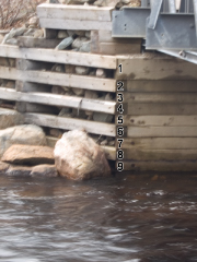
  • On the west coast of the island a small crew tackled White's River, the upper section of Lomond River, and Bakers Brook over the long weekend in May. These three classics are located within a couple of hours of Cornerbrook along the Viking Trail into Gros Morne National Park. The rivers are grade IV to V and include abundant class IV and V rapids that consist of boulder gardens, ledges and large waterfalls. This is a great long weekend trip if you're looking to raise your adrenaline levels. I'll post more details about all three rivers over the next month or so. But an important development is a gauge for the Whites River. Kev and I put-on the river when 9 boards were exposed on the river right bridge footing. We figured this was a good level for the two canyons. The Whites can be run as low as 9.5 boards and anything higher than 8 boards significantly increases the difficulty of the canyons.

Whites River Gauge. River right bridge footing.

  • The Northwest River flowed at reasonable levels for most of August and several trips were made in the warm summer sun. Of note this summer is that people began regularly running the river centre falls on the 2nd Golf Course Rapid. This 5 m waterfall has a somewhat manky and hard to scout lead-in. Dave and Darren tell me that once you're lined up on the final ramp that it is a really fun drop.